
Geography
Map reading: Kestrel Vale with teacher notes
Use the fictional Kestrel Vale map to practise grid references, compass directions, measured distances and a route description. Compare three car-park sites using map evidence, then check responses with the separate teacher notes.
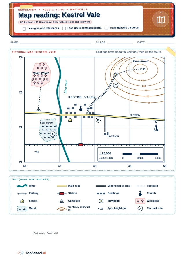
Fictional map: Kestrel Vale. Use the full PDF at its printed scale for distance measurements.
Read the complete materialRead the material
Use the fictional Kestrel Vale map to practise grid references, compass directions, measured distances and a route description. Compare three car-park sites using map evidence, then check responses with the separate teacher notes.
Student activity: UK, print scale corrected. Use the preview for diagrams and layout.
Page 1
NAME
CLASS
DATE
GEOGRAPHY
AGES 11 TO 14
MAP SKILLS
Map reading: Kestrel Vale
Map reading: Kestrel Vale
NC England KS3 Geography: Geographical skills and fieldwork
I can give grid references.
I can use 8 compass points.
I can measure distance.
N
FICTIONAL MAP: KESTREL VALE
Eastings first: along the corridor, then up the stairs.
186
186
48
48
61
61
80
80
100
100
120
120
140
140
160
160
A
B
C
N
1:25,000
0
500 m
1 km
4 cm = 1 km
KESTREL VALE
KESTREL VALE
Raven Knoll
Raven Knoll
Hollin Wood
Hollin Wood
Kest Marsh
Kest Marsh
River Kest
River Kest
Low Farm
Low Farm
to Hexley
to Hexley
46
47
48
49
50
21
22
23
24
KEY (MADE FOR THIS MAP)
River
Main road
Minor road or lane
Footpath
Railway
Station
Buildings
Church
School
Campsite
Viewpoint
Woodland
Marsh
100
Contour, every 20
m
186
186
Spot height (m)
A
Car park site
Page 2
Use the lines at the bottom-left corner of the square:
easting, then northing.
EXAMPLE School: 4722 (47 along, 22 up).
a) Station
b) Campsite
c) Viewpoint
d) What covers most of 4623?
Stand on the first place. Which way is the second?
N
NE
E
SE
S
SW
W
NW
a) Church to viewpoint
b) Church to school
c) Low Farm to church
d) Church to campsite
47
48
3
22
23
2
Split the square into tenths. Count
tenths along, then up. School:
473222
a) Church
b) Viewpoint
c) Station
d) What is at 483218?
Measure centre to centre. 4 cm = 1 km: divide by 4.
a) Church to station
=
b) Church to campsite
=
Go further: church to
viewpoint
=
GEOGRAPHY
AGES 11 TO 14
USE THE MAP ON PAGE 1
Find it, measure it, explain it
Find it, measure it, explain it
1
Four-figure refs
3
Compass directions
2
Six-figure refs
4
Distance
cm
km
cm
km
cm
km
5
Describe a route
Station to viewpoint by road: give directions, distances, features.
Q5
6
Why here?
Give two reasons why Kestrel Vale grew
where it did. Use map evidence.
Q6
7
A new car park
Choose site A, B or C. Give a reason for it
and one against the others.
Q7
Page 1
Q
HOW IT FOLLOWS FROM THE MAP
ANSWER
1a
Station symbol sits between eastings 47
and 48, northings 21 and 22
4721
1b
Campsite tent: between 46 and 47, 22 and
23
4622
1c
Viewpoint: between 48 and 49, 23 and 24
4823
1d
Trees fill the square west of the river at the
top left
Hollin
Wood
2a
Church: 6 tenths past 47, 5 tenths past 22
476225
2b
Viewpoint: 6 tenths past 48, 5 tenths past
23
486235
2c
Station: 6 tenths past 47, 5 tenths past 21
476215
2d
3 tenths past 48, 8 tenths past 21: the
farmhouse
Low Farm
3a
1 km east and 1 km north of the church
NE
3b
0.3 km west and 0.3 km south
SW
3c
From the farm: 0.7 km west and 0.7 km
north
NW
3d
Same northing, 1.2 km further west
W
4a
Due south, 1 grid square: 4.0 cm ÷ 4
1.0 km
4b
Due west: 4.8 cm ÷ 4
1.2 km
Accept one tenth either way in the last digit of each six-figure part
(for example 475 to 477). Distances: accept 0.1 km either way. Go
further: 5.7 cm, about 1.4 km (the diagonal of one grid square).
Talk question: the village is on the east bank, but the
campsite is on the west bank near the marsh. Is that a
sensible place for tents? What would you check first?
SUPPORT AND STRETCH
Support: give a tenths ruler (a 4 cm strip split into 10).
Stretch: ask for the six-figure reference of their
chosen car park site, and why the lane (about 1.4 km)
is longer than the straight line.
Print at actual size (not "fit to page") so grid squares
measure 4 cm. Kestrel Vale and its key are fictional,
not Ordnance Survey symbols.
TEACHER PAGE
ANSWERS CHECKED AGAINST THE MAP GRID
Map reading: teacher notes
Map reading: teacher notes
NC England KS3 Geography: Geographical skills and fieldwork
1
Answers: tasks 1 to 4
SIX-FIGURE POSITIONS USED TO DRAW THE MAP
School
473222
Church
476225
Station
476215
Campsite
464225
Viewpoint
486235
Low Farm
483218
Site A
468218
Site B
481222
Site C
486232
Use these to check any pupil's own references, for example
for the site they chose in Q7.
2
Model answers 5 to 7
From the station go north on the minor road for
about 850 m into Kestrel Vale. At the main road,
with the church ahead, turn right (east). After
about 150 m turn left onto the lane and climb
north-east about 1.4 km, past spot height 61, up
Raven Knoll to the viewpoint. Look for: directions,
distances and features.
Q5
A bridging point: the main road crosses the River
Kest here. A dry site: the village is on the east
bank, out of Kest Marsh and the flat floodplain.
Flat land below the 80 m contour is easy to build
on. Roads meet here, and the railway has a
station close by. Look for: two developed reasons,
each backed by map evidence.
Q6
B is the strongest: beside the main road, flat, dry
and close to the school, church and station. A is in
the marsh beside the river, so it may flood and
would damage wetland. C is up a narrow lane on
a slope, far from the village. Credit C if argued for
viewpoint visitors with its problems named.
Q7
COMMON ERRORS
Northings first: 2247 instead of 4722. Say "along
the corridor, then up the stairs".
Wrong corner: using the top or right line, giving
4822 or 4723. The square takes the numbers of its
bottom-left corner.
Six-figure: counting tenths from the wrong line, or
giving the northing first (225476).
Distance: forgetting to divide by 4, or measuring
along the lane.
A teaching sequence
Locate places with four- and six-figure references, describe direction and distance, and justify a site choice with evidence from a fictional map.
Fictional map: Kestrel Vale. Use the full PDF at its printed scale for distance measurements.
Read the complete materialRead the key and four figures
Read the map key and locate the station, campsite and viewpoint using the bottom-left corner of each square. Say the easting first, then the northing.
Are you reading easting first, then northing from the bottom-left corner?
Fictional map: Kestrel Vale. Use the full PDF at its printed scale for distance measurements.
Read the complete materialLocate with six figures
Divide a square into tenths and locate the church, viewpoint and station with six figures. Check what lies at 483218 and discuss why the order of the two coordinates matters.
What do the tenths add to the four-figure square reference?
Check directions and printed distance
For directions, start at the first named place and look towards the second. Measure distances centre to centre on the corrected print and divide centimetres by four to obtain kilometres.
Does a printed grid square measure 4 cm before you divide by four?
Explain the route and trade-offs
Describe the road route from station to viewpoint with directions, distances and features. Ask pupils for two map-based settlement reasons and a car-park recommendation with a reason against alternatives.
Which map detail supports your site choice and a reason against another?
Before you teach
Look for the thinking behind an answer, choose the support your class needs and leave room for an independent response.
What to look for
Use the teacher notes to check station 4721, campsite 4622, viewpoint 4823 and the six-figure positions. Church to station is 1.0 km, church to campsite 1.2 km and church to viewpoint about 1.4 km. Accept the stated tenths and distance tolerances. For the route and site choice, ask which mapped feature supports each reason; the teacher notes favour site B and allow a reasoned alternative.
Give a little support
Model along then up with the school example. Give a 4 cm strip divided into ten equal parts to practise tenths, and trace the route before asking for a written description. Work through one distance calculation together.
Take the idea further
Ask pupils for the six-figure reference of their chosen car-park site. Compare the lane distance with the straight line and explain why they differ. Use the campsite question to distinguish map evidence from checks that would need a real site visit.
Things to keep in mind
Kestrel Vale and its key are fictional; the symbols are not presented as Ordnance Survey symbols. Print the student PDF at Actual size or 100 percent and verify that a grid square measures 4 cm. Resizing changes ruler measurements. The map supports reasoned explanations rather than proving why a real settlement grew or where a real car park belongs.
Keep the idea. Make it yours.
Bring your topic, learning goal and class context to PLAI™, then review what you create.
Another starting point
Explore a different teaching task from this selection.
Map reading: explore fictional Kestrel Vale
Print at actual size and measure a grid square: it should be 4 cm. Locate the school example, first as 4722 and then as 473222, before beginning the questions.
Explore resourceIdeas for using this resource
Sample teaching perspectives on what to try, what to adapt and what to watch for.
Meet The Creators
Meet the creators whose teaching interests connect with this template. Find an approach to try with your class.
Struan Whitelaw
I lead Geography across secondary and teach a Year 8 unit on the Mekong Delta in coordination with Vietnamese Studies.
Meet the creator
Narin Kittisak
I begin Geography and Global Perspectives inquiries with local places, maps and field observations, asking pupils to compare evidence and identify what their account still needs to establish.
Meet the creator
Ewan Tasker
I use local Geography fieldwork with data-processing support that leaves interpretation to pupils, asking what observations show and how securely they answer the geographical question.
Meet the creator
Gareth Pryce
My classroom work is Year 7 Geography, so transition is not an abstract process for me: it meets pupils in the routines and subjects they encounter when they arrive.
Meet the creator
Planning List
The fictional Kestrel Vale map includes a scale, north arrow, key, grid and land features such as a marsh, railway, school and campsite. The teacher-notes edition should be kept distinct from the pupil-facing map when preparing answers.
The Curious Pencil
The map supports KS3 skills in grid references, compass directions and measured distance. The easting-first reminder (along the corridor, then up the stairs) gives teachers a phrase to reinforce the order before pupils work independently.
Chalk & Chai
The scale of 4 cm to 1 km and eight compass points let staff model one reference and direction before setting the remaining tasks. The key identifies features specific to this fictional landscape.
Organised Pile
Kestrel Vale is a fictional 1:25,000 map with grid references, a scale bar and eight compass points. Keep teacher notes separate from pupil answers and check the printed grid and scale before measuring a route.